Fort Cumberland, Maryland — two-volume history book
"Fort Cumberland" is available in print and Kindle editions. It provides expanded insights into early western Maryland history.
A deeper look at the history of Cumberland, Maryland
Fort Cumberland was erected along the North Branch of the Potomac River at the mouth of Wills Creek in 1754, forming the nucleus of what would eventually become the town of Cumberland, Maryland. The fort, and early commercial activity at Wills Creek, played an outsized role in shaping the destiny of North America.
Lannie Dietle's 982-page two-volume book "Fort Cumberland" is the definitive reference on the military and civilian history of the fort and its environs prior to the founding of the town of Cumberland, Maryland. The book achieves this status by presenting abstracts of and excerpts from original French and British documents in chronological order, immersing the reader in history through the eyes of the individuals who experienced it firsthand.
Content and organization of the book
The book commences by tracing the non-native settlement of the region beginning in 1722, when escaped slaves found refuge from their former masters at King Opressa's Town — an Indian village that is now the site of Oldtown, Maryland. Parallel chapters cover the pre-1754 timeframe. One chapter documents the development, extent, and individual members of a surprisingly litigious agriculture and trade-based frontier community. The other documents the complex factors that brought a devastating genocidal war to the region — the French and Indian War.
Individual chapters cover the 1754 to 1786 military and civilian history of Fort Cumberland and the surrounding region on a year-by-year basis, with a level of detail never before attempted. In these chapters you will witness the initial whirlwind construction of the fort, you will understand the weaknesses inherent in its construction and location, and you will learn about radical alterations designed to overcome those weaknesses and make the fort more defensible. By reading military letters, diaries, contemporaneous newspaper accounts, etc., you will learn about the military roles Fort Cumberland fulfilled during the French and Indian War, Pontiac's Rebellion, Lord Dunmore's War, and the Revolutionary War — and the many trials and tribulations of frontier military service. You will come to understand the horrific civilian massacres that occurred throughout the region, and how those experiences influenced subsequent relations with Native Americans. You will learn about the role of Fort Cumberland and the soldiers who were stationed there during the Forbes expedition. You will develop an understanding of the rapid post-1758 recovery of the non-native population, which established the conditions necessary for the founding of the town of Cumberland. You will also come to understand the Fort Cumberland-related roles played by Thomas Cresap, George Washington, Robert Dinwiddie, Horatio Sharpe, James Innes, John St. Clair, Edward Braddock, Robert Orme, Charles Spendelow, Charlotte Bristowe Browne, Thomas Dunbar, John Fraser, Charles Lewis, Adam Stephen, John Dagworthy, Henry Bouquet, Richard Pearis, James Kenney, James Burd, James Livingston, Enoch Innis, Lemuel Barrett, and other men and women.
Volume 1 (482 pages) of the print edition covers the history of Fort Cumberland and its environs through 1757, including the 1755 expedition of General Braddock and the heart-wrenching massacres of settler families near Fort Cumberland. A chapter on early roads and paths near Wills Creek is also included. Volume 2 (500 pages) focuses on the 1758 to 1786 time period, including fascinating information about the participation of western Maryland in the Revolution. Volume 2 also includes a modest amount of material dating from the 1787 to 1898 time period, including early descriptions of Cumberland. The chapter also presents incisive information about the tradition of George Washington's headquarters at Cumberland during the Whiskey Rebellion. Click here to see the Table of Contents of Volume 1. Click here to see the Table of Contents of Volume 2.
This exciting new Cumberland history book is available in both print and Kindle editions. Click here to learn about the various ways the Kindle edition can be viewed.
All proceeds benefit the Allegany County Historical Society — an education-based 501(c)(3) non-profit organization located in Cumberland that is dedicated to the discovery and interpretation of historic resources in the mountains of western Maryland.
Mr. Dietle's book is a significant contribution to the written history of western Maryland.
Originally from the Wellersburg area, near Cumberland, Maryland, Mr. Dietle's interest in history began as a youth, from discussions with his grandparents, and the purchase of two 1860s books about the Civil War at a rural auction. He is a descendant of the earliest settlers in southern Somerset County, Pennsylvania, and has pursued a lifelong study of the history and geography of the region. Both sets of grandparents lived on farms that were located on the waters of Wills Creek.
Mr. Dietle graduated from California University of Pennsylvania (now Pennsylvania Western University) with honors at age 20. He worked 48 years in the petroleum industry, retiring at the end of 2020. As Principal Designer at a Texas-based engineering firm, he has been awarded 40 U.S. patents related to oilfield technology. His rigorous approach to industrial research guides his evidence-based approach to historical writing.
In a discussion of William H. Lowdermilk's 1878 book "History of Cumberland (Maryland)...", Mr. Dietle expressed his impression that the inhabited place known as Fort Cumberland was "a supply center for the surrounding region, long before the first decade of the 19th century." In response, someone asked if that was true, then "...who was doing the supplying and where did they live?" The answer was unknown, and the question inspired the research on the early settlers in the Wills Creek area that ultimately led to writing the two-volume book "Fort Cumberland".
Bonus Fort Cumberland-related material
Click here for Robert L. Bantz's recommended reading list for French and Indian War-related western Maryland history.
Description of Fort Cumberland, Maryland
The following one hour and nine-minute video describes the history and construction of Fort Cumberland and related outbuildings atop a hill on the west side of the mouth of Wills Creek. It also describes how the original 1754 palisade fort evolved into an earthen fort over time. The video is primarily based on information from Mr. Dietle's book "Fort Cumberland". Topics covered by the video (and the book) include the reason for the fort, who built the fort, the size of the fort, drawings of the fort, defensive weaknesses of the fort, Ohio Company buildings, locations of parade grounds, powder magazine location, size, type, location, and number of cannons, storehouses at the fort, guard rooms, officers' quarters, bridges at the fort, a well at the fort, houses for rent, outhouses at the fort, outer defensive works, the ravelin and other cannon-proofing earthworks, the magazine explosion, repairs using fascines, deterioration of the fort over time, and Washington's headquarters cabin. For best results, view on YouTube in high-definition mode.
Western Maryland in the Revolution
The Turkey Foot Road was cut northward from Fort Cumberland during the Revolution to resupply a desperately undersupplied Fort Pitt. The creation of the road and the use of Fort Cumberland as a supply depot were previously unknown western Maryland contributions to the war effort. The following one hour and 48-minute video provides a brief description of the military origin of the Turkey Foot Road and then details its route northward from Fort Cumberland using maps, photographs, and anecdotes. For best results, view on YouTube in high-definition mode.
The location of Fort Cumberland, Maryland
"Emmanuel Parish"), which is situated on the eastern end of the site of the fortified barracks portion of Fort Cumberland at 39.65063266, -78.76535011, overlooking Wills Creek. The approximate location of the bastioned portion of the fort is 39.65081365, -78.76617951. Click here to see a YouTube video by James Blake that provides a tour of earth and masonry features under the Emmanuel Episcopal Church that are thought to be artifacts of the fort.
This church (Emmanuel Parish) overlooks Wills Creek from the site of Fort Cumberland — a British fort during the French and Indian War. Construction of the current church building commenced in 1849 and the building was consecrated on October 16th, 1851 — making it an important part of Cumberland, Maryland history in its own right.
This is a tunnel extending from the eastern end of the basement of the Emmanuel Episcopal Church in Cumberland, Maryland. The tunnel exits the hillside on the bank above Wills Creek. It is believed to be a surviving feature of Fort Cumberland that was intended to provide a safer approach to Wills Creek to obtain water. A 1756 document mentions the recent creation of such an underground passageway.
Where was Fort Cumberland, Maryland located? This is an 1898 drawing showing the approximate location of Fort Cumberland relative to the streets and waterways of the town of Cumberland, Maryland. The Emmanuel Episcopal Church is curently located where the barracks portion of the fortification is illustrated.
A digital library of material related to the history of Fort Cumberland, Maryland and its environs:
This is a collection of materials that may be of interest to individuals who are studying the history of Fort Cumberland, Maryland and pioneer settlements in the surrounding region. Since Maryland is quite narrow where Fort Cumberland was situated, a study of its environs necessarily encompasses nearby portions of Pennsylvania and West Virginia. I have also included history books that provide descriptions of important events elsewhere in North America that influenced the history of Cumberland, Maryland.
"History of Cumberland (Maryland)...": Will H. Lowdermilk, 1878 (25.3 MB). One of the reasons the "Fort Cumberland" book was written was to cover early periods of Allegany County history that Lowdermilk's "History of Cumberland..." book skips.
"The History of the Cresaps": Joseph & Bernarr Cresap, 1937 (66.8 MB) This and Mr. Dietle's "Fort Cumberland" book contain information regarding the early western Maryland pioneer Colonel Thomas Cresap.
"History of Western Maryland" (Volume 1,
Volume 2): J. Thomas Scharf, 1882 (66.9 MB) For Allegany County history see Volume 2.
"As I Remember and Other Reminiscences": Sarah S. Adams, 1904 (4.7 MB); See the June 1755 letter written from Martin's Plantation, beginning on page 39.
"The Kentucky Rifle": John G. W. Dillin, 1924 (html); See the information about western Maryland riflemen during the Revolutionary War in Chapter 14.
To learn more about Fort Cumberland on Wills Creek and its role in the French and Indian War and other conflicts, see the book promotion Facebook page.
 "Fort Cumberland" is available in print and Kindle editions. It provides expanded insights into early western Maryland history.

 Mr. Dietle's book is a significant contribution to the written history of western Maryland.
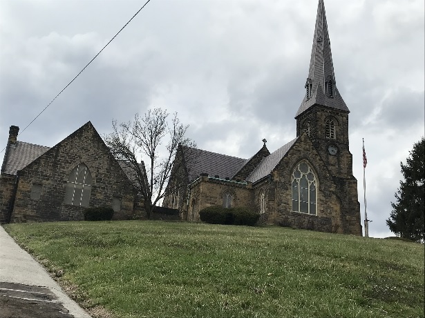 This church (Emmanuel Parish) overlooks Wills Creek from the site of Fort Cumberland — a British fort during the French and Indian War. Construction of the current church building commenced in 1849 and the building was consecrated on October 16th, 1851 — making it an important part of Cumberland, Maryland history in its own right.
 This is a tunnel extending from the eastern end of the basement of the Emmanuel Episcopal Church in Cumberland, Maryland. The tunnel exits the hillside on the bank above Wills Creek. It is believed to be a surviving feature of Fort Cumberland that was intended to provide a safer approach to Wills Creek to obtain water. A 1756 document mentions the recent creation of such an underground passageway.
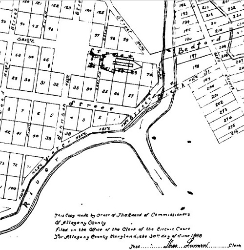 Where was Fort Cumberland, Maryland located? This is an 1898 drawing showing the approximate location of Fort Cumberland relative to the streets and waterways of the town of Cumberland, Maryland. The Emmanuel Episcopal Church is curently located where the barracks portion of the fortification is illustrated.
