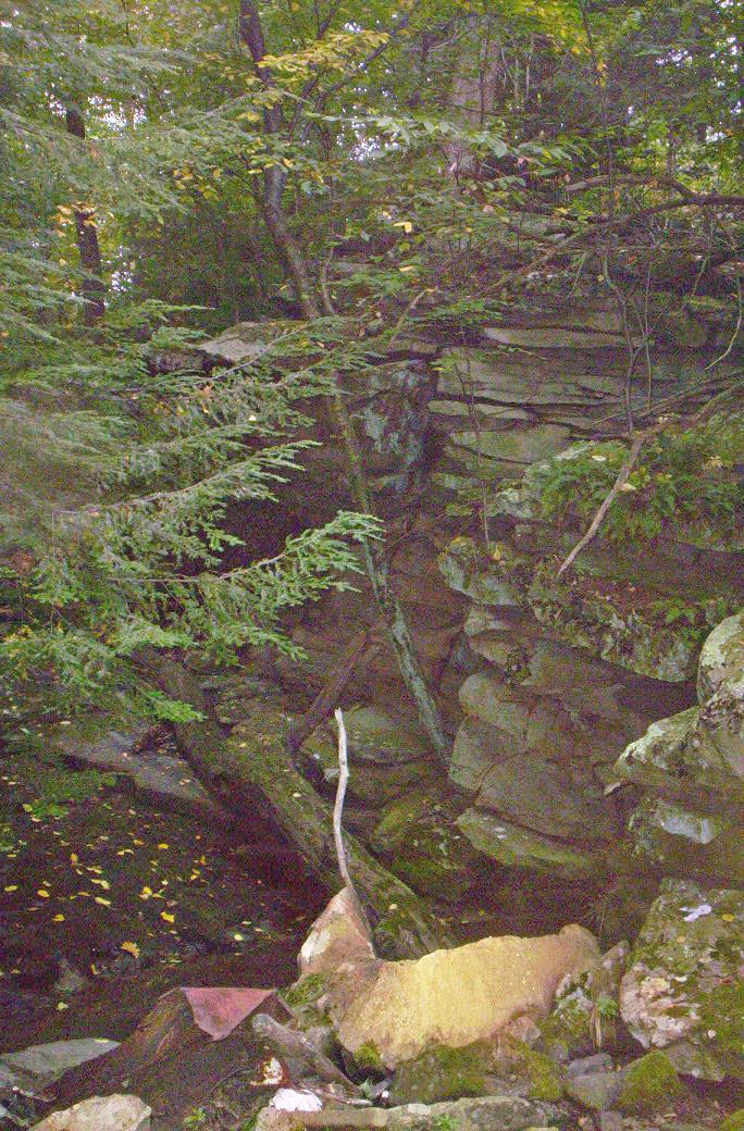
Mike McKenzie took the various photos below in 2009. They pertain to four puzzling rock stacks that have been located on one side of the steep-sided, fairly wide gully that is shown in the next photo below. This gully is located down over the hillside on the south side of Route 160, at a location that is between the Grand View Road and the Glencoe Road, in Southampton Township, Somerset County, PA. The picture was taken from a vantage point that is just above where the Matthew Lane crosses the water, looking up at the edge of the gully where the rock piles are located.
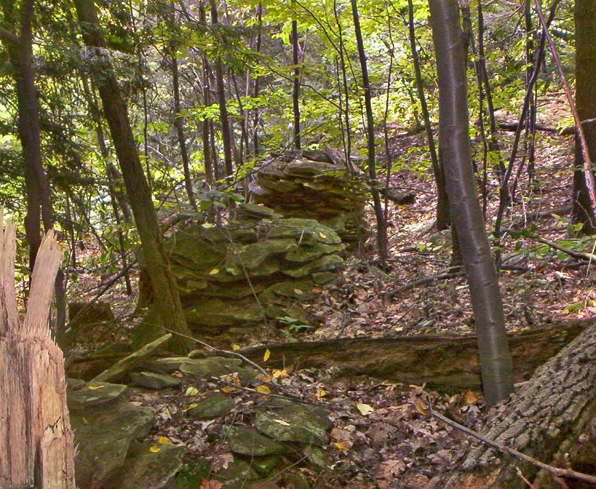
The next two photos show several of the stacks of rocks from different vantage points. The large rock in the background of the first photo is propped level with a smaller rock, and is aligned with one of the rock stacks that is closer to the photographer. Those two stacks are closest to the edge of the gully. The stacks of smaller rocks in the first photo below are clearly situated in leveled spots in the hillside, and do not appear to use any mortar. We do know that there was some type of wooden structure associated with these rock stacks, because machine-cut square nails, square-shanked bolts and a single flute twist drill were found at the site; click here to see them. The bolts suggest that whatever the structure was, it was well-built. Regarding the hardware, Mike reports "All these items were right around the stacks a few feet on the upper slope and one of the bolts was right up near the edge of the gully". He also wrote "...the closest bolt to the edge of the gully was no more than 4 feet from the large rock that is perched there. all the other items were located just a few feet back from the edge, and very close the piles of rocks.". The edge mentioned here is the edge of the gully that is shown in the gully photograph above. The second photo below shows that one of the three stacks of smaller rocks has collapsed.

The purpose of the rock stacks is a mystery. There are no old mine remains above these stacks, so they don't appear to have anything to do with mining. Mike has seen at least 3 old maps that show a road crossing the creek that formed this gully, and the path of that creek has a destinctive shape that all of the maps seemed to show clearly. One possibility, therefore is that the rock stacks were intended to be foundations to support framing for a bridge to cross the gully.

If the purpose of the stacks was to support a bridge, I would have thought that they would be more sturdily built. On the other hand, perhaps what remains is only the core material of the foundation, and the outer rock has been salvaged. It is possible that they were salvaged for other purposes, such as a retaining wall that is visible on an old, abandoned roadbed that is only about forty feet above the rock piles. If there ever were side-by-side pairs of these stone stacks that were later salvaged, we might still be able to find the leveled spots that were prepared for them (but this wasn't thought of at the time the photos were taken so no search was made). If a road did cross this creek in this area, Mike reports that "...a crossing would have been more viable just above these stone piles. ". This fact likely means that a bridge at the location of the rocks just doesn't make good sense.
If these rock stacks were for a bridge that had actually been built, one would also to find expect similar structures on the other side of the gully, or perhaps some leveled spots to receive them. Mike explored the far side of the gully and reported "I went across the gully, couldn't find any evidence of stone stacks or anything, didn't pick up any hits on the metal detector, but didn't search long, that side of the gully is confusing because it is all a rocky slope, if there was a bridge here it would have to have been a large and long one due to the terrain". In the next photo, Mike was close to the edge of the gully, looking out across the large rock and other stacks and towards where the 135-degree bend is shown on the 1939 aerial photo that is shown further down on this page.

About forty feet above the rock stacks is an abandoned road bed that appears to be fairly old, and above that is current day (2009) Route 160. Stones are stacked up along the lower side of that abandoned roadbed to create a retaining wall. The study of the four rock stacks has morphed into a study of the early nearby roads because we have been trying to determine if the stone stacks had anything to do with the old roads.
One thing for sure, the rock stacks were here for some reason that must have seemed potentially worthwhile at the time they were built. No one expends that kind of effort unless there is a perceived benefit. If someone was just gathering rocks for a house foundation to be located somewhere else, they wouldn't have stacked them like that, or leveled out spots to receive them. They would probably have put them directly on a wagon or sled, or piled them loosely in a heap to await such transportation. The rock stacks do not look much like the start of a stone fence, a retaining wall, or a building foundation either. The sketch below was made by Mike to show the location of the three stacks made from smaller rocks. He traced the 1939 roadbed by holding the paper up to a 1939 aerial photo that was on his computer screen. The sketch indicates that the stacks are in approximate alignment with a a nearby 135-degree bend in the 1939 road.

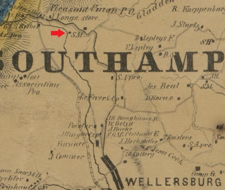
The image below is from the 1860 Walker map, and shows a sawmill at the exact same location as the rock piles. This seems to prove that the rock piles are associated with the 1860 sawmill.
The image below is from the 1841 Walter Rogers Johnson map from the "Report of a survey and exploration of the coal and ore lands belonging to the Allegheny Coal Company: in Somerset County, Pennsylvania; accompanied by maps, profiles and sections". Although the map is not to scale, it shows a Witt sawmill at approximately the same location as the 1860 sawmill. This strongly suggests that the rock piles are part of the 1841 Witt sawmill.
The photo below is the 1939 USDA aerial photo of the area. The distinctive L-shaped region that is heavily forested is the gully. The red dots represent the current location of Route 160. These red dots were established by scaling and overlaying a current Google aerial photo over the 1939 photo, then tracing current roads onto the 1939 photo. I believe that the superimposed modern-day roads are extremely accurately depicted. The yellow dots on the right represent the current location of Grand View Road. The yellow dots near the middle represent the current day grown-over Mathew Lane, or at least represents the way it is shown on a current Google aerial image. The bow in the middle is the path of Matthew Lane that Google has overlaid on their aerial photos, but isn't the actual path of the lane that can be seen in the Google photo. Mike has confirmed that the lane goes straight across the gully, and doesn't have the loop. He says that Mathew Lane is definitely a bulldozed road that has the appearance of a logging road, and is quite narrow. He knows it was bulldozed by the way it plows through rocky areas.
Note the faint trace of an old generally east-west roadbed that crosses the gully in that same area; this road is marked with light green dots. That old roadbed may have curved up to the join the 1939 roadbed at the 135-degree bend in the 1939 roadbed. A faint trace of an abandoned roadbed can also be seen further down; this roadbed is marked with small blue circles. Above Route 160 a clearly visible cleared path or road that extends from the area of the current day Cabin Hill Road, and meets up with the location of the current roadbed near the gully.
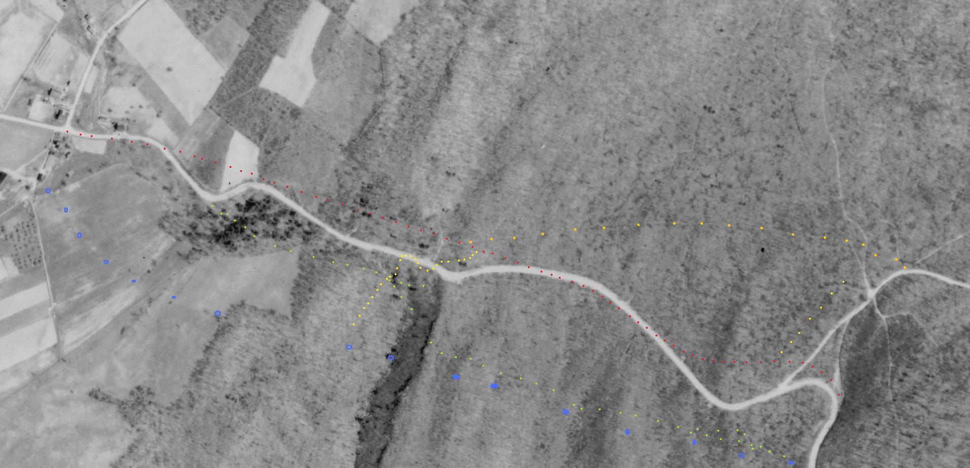
On the 1876 Beers map of Southampton Township (see relevant portion below), the road that is illustrated does not cross the water at this gully. Instead the 1876 road passes above the stream, and therefore above the gulley, and obviously has the same shape as the 1939 road, with the minor exception that the 1939 road is curved at the intersection with Grand View road, and the 1876 road is not. Put all of this information together, and it tells us that abandoned road bed that is located between the rock pile and current day Route 160 was the 1936 route and also the 1876 route. There is another abandoned road bed below the rock stacks that is not represented on the 1939 aerial photo above. This lower road bed gives Mike the impression that it was bulldozed, which may mean that it was a logging road or an older abandoned road that was later bulldozed to serve as a logging road.

Circa 1832 the Somerset and Cumberland Turnpike was built through this general area, and later, circa 1850-54 at least some portions of that turnpike was converted into what is still known as the Plank Road. Being constructed not that long before the 1876 map, it is very likely that the Plank Road and the 1876 road were one and the same road.
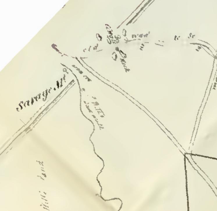
The map fragment shown below is from the 1841 Walter Rogers Johnson map from the "Report of a survey and exploration of the coal and ore lands belonging to the Allegheny Coal Company: in Somerset County, Pennsylvania; accompanied by maps, profiles and sections". This map, although grossly out of scale, also shows the road passing above the gully. This tells us that the circa 1832 turnpike passed above the gully, and may be the same route as the plank road, the road on the 1876 map, and the road that shows up on the 1939 aerial photo. In other words, this is the abandoned road bed that is located about 40 feet above the rock stacks. The Johnson map also shows a diagonal road that is marked "old road"; this may possibly correspond to the diagonal road above Route 160 that is identified by orange dots on the 1939 photo above. Note that on the 1876 map and the 1939 aerial photo, Grand View road splits into an upside-down Y where it intersected with Route 160. The Johnson map seems to make it clear that the right-hand branch of the upside-down Y was what was in use in 1841.
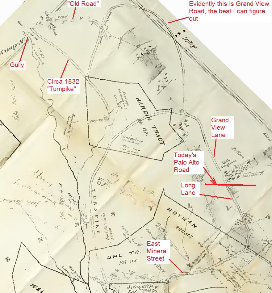
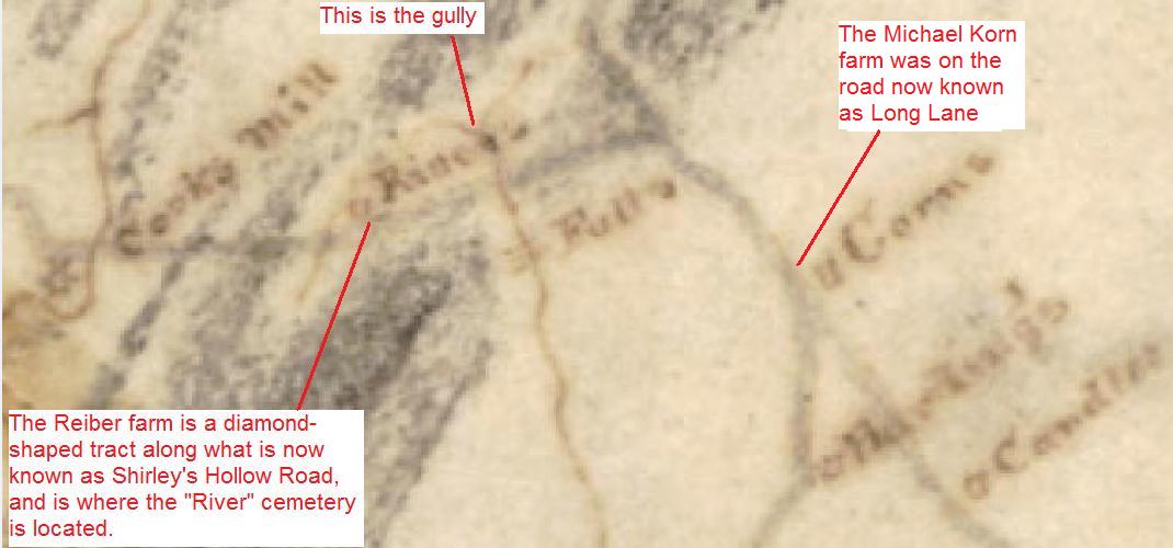
The map fragment shown below is from the 1818 Whiteside map. On this map, the pre-turnpike road is shown to be crossing the creek. This suggests that the abandoned roadbed that is marked with small blue circles may have been the 1818 route, because it crossed the creek. Of course, the road outlined in blue dots could be a logging road too; we can't be sure. Because the 1818 route crosses the gully, it is clear that whenever the 1876/1939 route was laid out (probably circa 1832), the roadbed was placed north of the 1818 route to avoid crossing the gully.
In the 1818 map, a Y of two smaller streams coming together is shown. We have not yet investigated to see where this Y is located relative to the stone structures. We haven't figured out what the rock stacks were for, but we have learned a lot more about the local roads. One possible theory is that this was somehow related to a toll house or some other structure associated with the turnpike or the later plank road, which passed above the gully. Mike theorizes that it would make sense to put a toll house at a location such as a bridge, or a rough area with steep terrain, so the toll house was difficult to simply bypass. The gully could have certainly served such a theoretical purpose, but we make no claim to know anything about the use or positioning of toll houses along this road. This is simply conjecture at this point, intended to try to link the remains to some known activity in the area. This was pretty much limited to activities such as timbering, saw, grist and woolen mills, agriculture, sugaring, distilling, mining, transportation, worship, and residential activities. The rock piles must surely relate to one of these basic categories of local activities, but they remain a puzzle. We know that there was a Witt sawmill somewhere near here circa 1841, but we don't know what the rock piles might have had to do with a sawmill.
L. Dietle, based primarily on information provided by Mike McKenzie.
September, 2009. Updated 2015.

Return to the Korns family genealogy home page
